

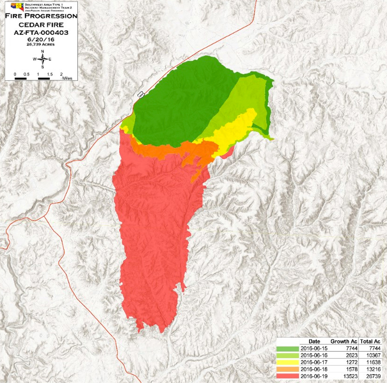
The Cedar Fire burning south of Show Low on the White Mountain Apache Indian Reservation continued to rage as crews fought hazardous fire conditions throughout the day on Sunday, June 19. According to information provided by the Incident Management Team the following day, the fire had grown to 26,739 acres since it started on June 15.
As of Monday, there were no evacuation orders, but the White Mountain Apache Tribe had placed the Cedar Creek community under a pre-evacuation notice. If an evacuation notice is given, Cedar Creek would be evacuated to Round Valley Middle School, located at 126 W. Second St. in Eagar, via Highway 73.
There are still pre-evacuation notices for Show Low, Pinetop-Lakeside, McNary and Hon-Dah as firefighters have been able to hold the line with burnout operations 10 miles south and southwest of those communities. Shelters are located at Snowflake High School at North Second Street West and at the Round Valley Middle School in Eagar for those who need to evacuate from those areas.
It was also reported that the perimeter of the fire on Monday extended directly south and east of Highway 60 across the Gila County/Navajo County boundary, and the eastern edge of the fire crossed over the Cedar Creek drainage. The southern perimeter was approximately 1½ miles east of Highway 73, and approximately 2½ miles north of the Cedar Creek community.
As of Monday, 23 fire crews, 37 engines, seven dozers, 11 water tenders, seven helicopters and four single-engine air tankers were assigned to the operation. A total of 770 personnel were involved in fighting the fire. The current perimeter of the fire extends directly south and east of Highway 60 across the Gila County/Navajo County boundary.
There is no report of containment, and the cause of the fire remains under investigation.
For up-to-date information on the Cedar Fire, go online to tribunenewsnow.com.